|
This plan focuses on the various planning issues which are currently
facing Kilmacow, and is a product of the local community, Kilmacow
Development Group and Kilkenny County Council. All groups have worked
and continue to work, in order to achieve a balanced and ordered
development of the village and its hinterland.
The need for this plan has arisen from the prolonged and extensive
development pressures which Kilmacow has experienced over the past
decade. These pressures have given rise to the proliferation of
low density one off housing which has detracted from the physical
and social amenity value of the area.
The problems associated with Kilmacow have been identified within
this Plan. These problems vary in importance in different areas
of the village and the Plan analyses the problems and sets out a
strategic framework for dealing with them. The end result constituting
a plan which will procure an ordered future for the village and
its residents.
| 2.0
The Village In Its Context |
The name Kilmacow in its most popular form is translated Cill Mhic
Bhuith, the church of the son of Buadhach. The lower village is
believed to be the older of the two settlements and one of the oldest
villages in the country.
Currently the parish of Kilmacow incorporates the four older parishes
of Dunkitt, Gaulskill, Kilmacow and Ullid. Kilmacow parish covers
an area of 10,357 acres. An intensive milling industry capitalised
on the power available from the Blackwater in the 18th and 19th
centuries. The final operating mill closed in 1980.
Kilmacow is situated in the low-lying area of south Kilkenny, close
to the border with County Waterford and approximately 6.5km north-west
of Waterford City. It lies almost equidistant from two major national
primary routes, the N24 Waterford to Clonmel route, and the N9 linking
the two cities of Kilkenny and Waterford. The R697 is the main route
linking the upper and lower village to Narrabaun while the R622
forms the major junction within the upper village linking this area
to Dangan. This location makes the Kilmacow area very attractive
for future development allowing easy access to the Waterford area
and with future infrastructural improvements, to the entire south
east region
The character of the upper and lower Village is enhanced by the
presence of the Blackwater River which is a tributary of the River
Suir. The Blackwater forms the spine for the older built up area
which occurs on the western banks of the river. In the past it has
been used as a major source of power for the milling industry, the
legacy of which is still evident in the village today. Currently
it is used as a source of hydro-electricity and also as an amenity
for local swimming and recreation. The Blackwater still retains
potential for further development. While the Blackwater is well
contained in its channel between the upper and lower villages, the
floodplain still remains unsuited to development, owing to its susceptibility
to flooding and unsuitable topography.
The river has acted as a barrier to development on the eastern banks
with the only through crossing point being in the lower village,
while access is provided to “The Farm” sports complex
in the upper village on a separate wooden bridge. Approximately
500m below the lower village the river becomes tidal.
The most elevated areas of Kilmacow are located in Dangan, with
overall heights ranging from 30m OD to 13m OD in the lower village.
Throughout the upper village, but particularly from the Dangan area,
prominent views of the Commeragh Mountains occur to the south west
and Tory Hill to the east, Moolum Rock and the Walsh Hills along
with the foothills of Carrigatubrid and Corbally woods. The church
spire in the upper village is also very prominent and forms a visual
link throughout the village. The lower village is less elevated
ranging from 18mOD to 13mOD. Owing to its lower topography prominent
views do not occur, with the river, the bridge and the village itself
being the dominant features.
In terms of environmental sustainability it is worth noting that
Kilmacow is situated above the boundary of a major extensive aquifer
and a minor local one, the former contained in dolomitised limestone
and the latter in sub reef limestone. Both of these aquifers are
deemed to be highly vulnerable, while the sub reef limestone has
increased permeability along the Carrick Syncline. These factors
place Kilmacow in an area of high groundwater vulnerability and
further the need for proper sewage treatment in this area of intensive
development pressure.
The overall layout of Kilmacow displays a marked distinction between
separate areas within the village. The overall form of the village
is linear stretching for approximately 2km but the bulk of development
has occurred in the area north of the upper village at Narrabaun
and Dangan. These areas have suffered most from recent residential
ribbon development. Despite this fact the upper village still retains
an intimate character in the immediate vicinity of the church with
a traditional streetscape winding towards the village junction.
Most commercial, educational and community facilities are located
in this area.
The lower village’s character is almost unique in the south
east region. Its traditional streetscape and intimate open spaces
retain a quality worthy of preservation, despite being marred by
dereliction. The only commercial activity in this area is a public
house while the local health centre is also located here.
The intervening area between the upper and lower villages still
retains a rural character and is currently in agricultural use.
This stretches along the R697 for approximately 1km. Located in
this area is a local supermarket and filling station, a small number
of residential buildings and “The Farm” sports centre.
Also located along this route are some old stone walls which further
add to the rural character.
The boundaries and edges to Kilmacow reflect the extent of excessive
ribbon development particularly in the upper village. The lower
village still retains a hard boundary with its countryside. To a
lesser degree the lower village has experienced the problems of
one off housing on all approach routes other than the R667 and R640
as both enter the lower village across the bridge. To date the area
between the upper and lower village remains undeveloped and this
maintains the lower village as a separate entity in itself. An attribute
regarded as being worthy of preservation.
This undeveloped tract acts as an effective southern boundary for
the upper village. Unfortunately the remaining boundaries are less
well defined with a proliferation of residential dwellings on all
routes through Dangan and Narrabaun. While the one off housing developments
detract from the rural aspect of the village, it must be noted that
a number of traditional agricultural homesteads do occur on the
approaches to the village. These significantly enhance the rural
character of Kilmacow and to a certain degree counteract the ribbon
development on the approaches to the village.
While not directly relevant to village definition, the level of
dereliction is quite noticeable particularly in the lower village.
Here the level is attenuated by the dereliction of the key sites
which tend to detract from the surrounding buildings. Seven buildings
are derelict in the lower village, three between the upper and lower
village, and two in the upper village.
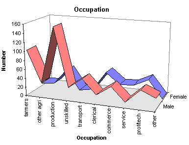
Despite Kilmacow being steeped with an industrial past owing to
its position on the Blackwater, its current prosperity owes much
to a strong agricultural base. In recent years there has been the
partial loss of the local creamery which now only functions in a
temporary capacity. Despite this agricultural employment still remains
the second largest employer in the area, with the largest proportion
working on farms above 50 acres. The other major employment areas
are those of production and manufacturing, with commerce, professional
and technical employment also playing large roles in employment
in the area as can be seen in the accompanying figures.
( Source 1996 census )
Education facilities in the village cater for those attending primary
level where two primary schools are located in the upper village.
Second level pupils are catered for in nearby Mooncoin and Waterford.
St Sennans boys school is well served with outdoor activity facilities
but, like St Josephs girls school, is lacking in indoor facilities.
There are concerns among parents regarding the lack of set down
and parking space at the boys school. This problem needs to be addressed
in the interest of safety.
Recreational facilities are provided in the area between the upper
and lower village and are run on parish lands on a community basis,
ensuring equal access for all. This centre has been in operation
since 1979 and in this period has been developed to include facilities
for athletics, hurling, football, soccer, skittle rings and tennis
courts. Changing facilities are also provided. These facilities
are enhanced by the provision of ample car parking and access via
the privately erected bridge. Currently new changing facilities
are being planned.
The planning issues and proposals for Kilmacow evolved from a programme
which involved the local community the Kilmacow Development Group
and Kilkenny County Council. in the plan preparation process through
discussions and meetings where valuable local knowledge was acquired.
A list of priority development issues which require attention in
Kilmacow was formulated. These are basically concerned with two
issues. Provision of adequate infrastructure and secondly the aesthetic
improvement of the village and its environs.
The Infrastructural deficiencies identified in Kilmacow are listed
below:
| Sewerage |
Roadsigns and markings |
| Public lighting |
Hedge trimming |
| Footpaths |
Collection of bulky domestic waste |
| Roads |
Youth club |
| Flooding |
Bus shelters |
Issues in Kilmacow relating to aesthetic improvements are as follows:
| Derelict sites |
Pond Area renovation |
| Renovation of old buildings |
Landscaping |
| Leisure and sports areas |
|
The above categories have been noted by the Council and have been
taken on board in the preparation of this plan. The plan endeavours
to cater for both the immediate and future strategic development
issues relating to Kilmacow, addressing the current development
control problems in what is anticipated to be a fully serviced area.
The revised development boundary has been established with this
in mind and will attempt to channel residential development into
the catchment area of the new sewerage scheme.
Increasing development pressures are expected in Kilmacow in the
near future due to improved access times to Waterford via the new
road network planned for the city. This will also provide free access
to the entire south east region for those wishing to live in Kilmacow.
More importantly these factors will improve the attractiveness of
the village for light industry. For Kilmacow to have a viable future
it must be able to capitalise on its strengths by firstly retaining
its rural rustic nature, by continuing to provide a viable community
spirit for all current and future residents, by providing adequate
choice of sustainable employment, and by channelling wealth generated
outside the village into locally provided services and amenities.
The following plan contains the Planning Authority’s policies
and objectives essential to the future orderly development of Kilmacow.
Kilkenny County Council recognises that Kilmacow retains a quality
of life, a community ethos, a rural character and a village scale
which are worthy of nurturing and protecting in any expansion of
the village. It is the intention of the Council that the policies
in this plan respect these characteristics and that all future development
within Kilmacow will be progressed in a sustainable manner in partnership
with the local community.
Current infrastructural provision within Kilmacow is seriously
deficient and unable to cater for development levels within the
village. The main thrust of this plan seeks to rectify this situation.
Kilmacow currently has no public sewerage scheme. All buildings,
private and commercial, are served by individual septic tanks. This
situation may be acceptable in areas of low density development.
It is unsatisfactory in Kilmacow where concentrated development
has taken place over the last number of years. This problem is particularly
acute in Dangan and Narrabaun where most of the development has
occurred. A large amount of this housing took place before the mid
1980s, with site sizes being under half of an acre. The majority
of these sites range from 0.2 to 0.4 acres and are below the minimum
site size for the efficient percolation of treated domestic effluent.
The Population figure within the Proposed Kilmacow development boundary
i.e. the catchment area of the proposed sewerage scheme, is currently
710 people while a total population of 1099 occurs in the immediate
area ( figures from July 1997 survey by Kilmacow Development Group
) These factors combined with the poor soakage in the area and the
substandard nature and maintenance of many systems, combined with
the acquifer vulnerability gives rise to public health concerns.
To date no evidence of ground water contamination has become apparent.
The question of the provision of this scheme has been ongoing since
the mid 1980s. The scheme currently proposed is dated from 1993
and has been updated to cater for current population pressures,
which is detailed in the policy section of this plan.
The Council is committed to the provision of a sewerage scheme
for Kilmacow, which is envisaged promoting the efficient and economic
servicing of residential areas. The implementation of this scheme
is dependent on the availability of public finance.
The Council is currently seeking funding to implement its sanitary
service objectives for Kilmacow.
The Council will encourage the economic use of the proposed sewerage
scheme for Kilmacow.
1. The Council proposes to sewer Kilmacow such that a natural outfall
for as many existing dwellings as possible is created, while also
creating the potential to service the maximum amount of undeveloped
land.
2. The main trunk sewer will run between Dangan and the upper village,
while individual spurs will link this to Narrabaun and the intervening
lands. These will be linked to the lower village along the R697
where other spur sewers will connect this to the outer areas of
the village. The entire network of sewers will be connected to the
treatment works located in lower Kilmacow on the west bank of the
river, upstream of the bridge.
3. Currently runoff from all existing development is channelled
into septic tank systems. The new sewerage system will cater for
this combined waste. In the case of new developments this situation
will not be acceptable. All such developments will be piped with
a system for foul waste and sewerage. A system for surface water
will remain separate to allow maximum capacity utilisation of the
treatment plant. It is the opinion of the Planning Authority that
grey water systems should be installed in all new developments and
that such conditions would be imposed on developments at their application
stage.
4. The original total design population equivalent for the treatment
works outlined in 1993 was 1228 persons by the year 2008 i.e. for
a fifteen year period. This figure has been increased to approximately
2000, the desired population which can be accommodated inside the
catchment area of the system. This area has been defined as the
maximum geographical extent which can be economically served by
the proposed system.
This is supplied by Kilkenny County Council from the Mooncoin Water
Supply Scheme at the reservoir in Clunassy, Mullinavat. Local residents
have been concerned as to the level of water extraction from the
Blackwater, especially at times of low flows. Present capacity of
the scheme is 1.1 million gallons per day, while current usage is
in the region of 0.65 million. Generally the quality of this water
is good however discoloration sometimes occurs.
The regional scheme has sufficient capacity to cater for the expansion
of the village.
The level of public lighting is sub standard. This deficiency is
owing to a combination of insufficient number of lamps and the substandard
quality of the existing ones. Between Narrabaun and the upper village
only two lamps exist which is regarded as substandard.
Similarly on the Dangan road public lighting is substandard and
haphazard and a concern to parents with children attending St. Sennans
school. Here again too few lamps are provided and the safety of
those using the road is compromised especially during the school
year as this route carries a large amount of school generated traffic.
A total of 9 lamps exist on this route many of them substandard.
All lighting within the upper village is substandard with many lamps
requiring replacement. This situation is particularly acute at junction
Lp3403-17, the main junction in the village. Here visibility is
already poor due to the protruding wall of the church grounds.
Additional lighting improvement is needed between the upper village
and the sports complex.
In the lower village the existing lamps are generally of good quality.
Any reinstatement of the footpath connecting the upper and lower
villages should be accompanied by adequate public lighting to allow
safe passage for all those using the supermarket and sports centre.
The Council will seek to redress the substandard public lighting
in Kilmacow, in particular the area between the upper village, Narrabaun
and Dangan will receive prioritised attention. All remedial works
shall be undertaken in conjunction with other road improvements
and sewerage scheme provision.
It is an objective of the Council to provide adequate public lighting
throughout the village but in particular at the upper village at
Narrabaun, Dangan in the vicinity of St. Senans school at the main
junction in the upper village and between the upper village and
the sports complex.
It is an objective of the Council provide adequate public lighting
between the upper and lower sections of the village in association
with the reinstatement of the footpath connecting the upper and
lower villages.
The existing provision of footpaths in Kilmacow is substandard,
it being incapable of catering for any future expansion in the area.
Recent improvements in the upper village have improved safety, visibility
and comfort for all users. Outside of this area with the exception
of cul de sac housing developments, relatively few footpaths exist.
Where they do they are in bad condition or badly sited on the wrong
side of the road and so do not adhere to pedestrian desire lines.
The footpath linking the village to the sports centre is substandard
and under-utilised as it is situated on the wrong side of the road
and pedestrians must cross outside the sports area or walk on the
roadside. Urgent attention should also be given to the provision
of a footpath between the upper village and Saint Sennans school.
This path should be provided on the same side as the school in order
to prevent pupils crossing the road outside the school. Traffic
congestion is already a problem in this area and a dangerous bend
occurs just north of the school set-down point. Here again an increase
in population numbers will add to the current problems. While new
facilities will also be required it is hoped that residential development
in the area between Narrabaun and Dangan will allow pedestrian access
from the Narrabaun area to the school thus relieving some pressure
from the village-school route. Throughout the remainder of the upper
village it is an objective of the Council to provide adequate footpaths
in order to allow safe use of the roads for the present and proposed
population. In the lower village a footpath is required and should
run along the southern side of the street between the bridge and
the R697 Waterford road. As mentioned in the previous section this
should be continued to the upper village along the route of the
old footpath, thereby allowing access to the filling station and
supermarket. Further provision of footpaths should be made on sections
of the Waterford road 697 and other routes 665 and 637. These will
be necessary to service new housing developments.
The council recognises the necessity for additional provision of
footpaths in Kilmacow. It also recognises that repair and upgrading
of existing footpaths is also urgently required. This does include
the reinstatement of the footpath between the upper and lower villages.
Works in this regard will be undertaken in conjunction with the
other infrastructural improvement works.
It is an objective of the Council to:
To make provision for a safe and adequate pedestrian network in
the village through the upgrading of existing and the provision
of new footpaths and pedestrian ways in the village.
The main roads into Kilmacow are primarily regional routes. Many
sections of these roads are in need of repair. Ponding of water
occurs in certain areas despite Kilkenny County Council having undertaken
successful remedial works in Dangan.
Maintenance of hedges on the approach routes to the village is also
another problem which must be addressed. In summer these seriously
encroach onto the public roads causing a narrowing of the carriageway
and conflict among road users. It has also been noted that there
is a general shortage of road markings throughout Kilmacow. Finally
there is a need to improve the junction Lp3403-17 due to the impaired
visibility and the anticipated increase in usage when development
occurs within the village.
The Council aims to improve the road network and other associated
infrastructural requirements within Kilmacow. The implementation
of these works such as road realignments, extension and improvement
of footpaths and lighting and the further curtailment of local flooding,
are dependant on the availability of public finance and will be
carried out in conjunction with the laying of the proposed sewerage
scheme.
It is an objective of the Council
1. To carryout improvements to the road network around Kilmacow
will improve access and safety throughout the village. Such works
will include flood elevation, resurfacing, realignment and trimming
of hedges. It is intended that such works will be carried out with
minimal interference to traditional stone walls, mature hedges and
other natural features.
2. To ensure that all new housing developments provide safe vehicular
and pedestrian access to the existing public road network. Entrance
treatments to any proposed developments will be such so as to prevent
a deterioration in road safety or compromise the character the village.
3. It will also be necessary to provide adequate signage throughout
the village and its hinterland, in order to improve safety and accessibility
for locals and tourists alike. Adequate signage is currently lacking
and the Planning Authority recognise the fact that proper speed
limit signs and town entrance signs are required so as to give a
defined boundary limit to the village as a whole.
4. To carry out a traffic management plan for the village in order
to deal with the problems identified in this plan such as existing
poor junction alignment, parking, pedestrian priority etc, thereby
making Kilmacow a more attractive and safer village for all road
users..
The problem of dereliction is particularly acute in the lower village
as many key sites are all in disrepair. While some work has been
undertaken in this area quite an amount still remains to be done.
A total of 7 buildings are deemed to suffer from dereliction in
the lower village. In particular one of the most derelict sites
is set out from the building line and forms the terminal vista for
all those travelling into the lower village across the bridge. It
is also quite prominent for those travelling in the other direction
giving this site a very high visual prominance within Kilmacow village.
General improvement has occurred on the left-hand side as one enters
across the bridge with complete renovation of one two storey residence.
The setback in the building line here provides a great opportunity
for landscaping and improvements. This could be carried to the area
adjacent to the Blackwater creating an attractive open-space for
residents and tourists alike. As already stated this area could
be highlighted to cater for niche tourist, arts and craft markets
and workshops thus creating a new element to life in the village.
Development of the river and bridge would also be essential to the
success of this area.
The Council will encourage refurbishment and conversion of existing
unfit, derelict and abandoned houses in order to improve the housing
stock and safeguard the fabric of Kilmacow.
The Council will subject to the availability of staff prepare design
briefs for such areas and where appropriate will acquire sites or
enter into joint venture or other partnerships in order to secure
their redevelopment to a high standard.
Where necessary the Council will acquire both by Compulsory Purchase
Order and by use of the Derelict Sites Act any obsolete properties
which in the opinion of the Council would continue to remain in
an unfit condition.
1. The Council recognises that eradication of dereliction is vital
to the development and enhancement of the village. The ownership
of these derelict premises has been identified. The County Council
will endeavour to offer assistance to these owners who wish to develop
their properties in keeping with policies set out in the current
development plan. Where necessary the Council will issue compulsory
purchase orders in respect of sites which are deemed to remain in
an unfit condition.
2. In the case of buildings which are deemed to be beyond repair
and where demolition is necessary, no change in building lines will
be allowed. New infill building structures dimensions will be required
to maintain established building and roof lines and proportions.
As dereliction is particularly acute in the lower village the council
will endeavour to prioritise any remedial measures in this area.
3. The extent of dereliction in the lower village is acute and improvement
is essential to the prosperity of the area. Full rehabilitation
and refurbishment will be sought for all derelict sites to ensure
the retention of the traditional village character. Where replacement
dwellings are proposed original building lines will be maintained.
It is essential that all derelict sites be improved, not in isolation
from their surroundings, but as part of an overall anti-dereliction
programme.
| 12.0 Private
Sector Housing |
Throughout the county it is the policy of Kilkenny County Council
to channel residential development, where possible, into adequately
serviced areas. To date this has not been possible in the case of
Kilmacow, with the sewerage scheme in place developments will be
encouraged to locate within the defined development boundary of
Kilmacow. Major infrastructural investment is viewed as a catalyst
for orderly growth of any settlement area and when in place it is
economic sense to utilise such investments.
Future developments within Kilmacow must meet the County Development
plan requirements of development control standards and design considerations
in order to further the proper planning and development of the village.
Part V of the Planning and Development Act 2000 (the Act) requires
that housing strategies be drawn up by planning authorities and
integrated into their development plans. The strategy is to have
regard to the proper planning and sustainable development of an
area and will be concerned with the overall supply of housing within
the administrative area of the Local Authority.
1. It is an objective of the Council to implement the housing strategy
contained in appendix A of the County Development Plan Vol. 1.
2. The Council will require that 18.7% of the land zoned for residential
use or for a mixture of residential and other uses be made available
for the provision of social and affordable housing.
| 13.0
Housing design Guidelines |
1. Owing to the large local community input in the plan and the
strong belief of the Council that both upper and lower villages
should remain separate, the majority of new developments will be
channelled into the area north of the upper village between Dangan
and Narrabaun, and areas with direct access onto the intervening
routes situated inside the development boundary.
2. Within the lower village less land will be available for development
and the majority of this land is highly sensitive to development
and should be treated in a sensitive manner by developers.
Housing layouts themselves should be of a spur type involving simple
cul de sac developments serving a small number of houses. The number
of houses depending on the site layout. Where possible site layout
will align topographic features and retain trees, streams and hedgerows
as natural features within the developments. This will be of particular
importance to the lower village as this area contains a large number
of distinctive natural features.
The Council will encourage a variety of house designs in all housing
development proposals. Individual house designs should reflect the
rural character of the village with the use of two storey housing
on the periphery of the village. In general all housing development
will be in line with County Council policies as outlined in the
County Development Plan.
In general in the County Development Plan there is no maximum nor
minimum density set for residential areas with the emphasis on providing
a quality housing environment based on innovation and a design led
approach.
For Kilmacow it is an objective of the Council that housing provided
would be such as to provide a quality housing environment based
on innovation and a design led approach
Given the nature of how the village has developed in the past and
in order to ensure that new developments will reflect the general
ambience of the area a density of 5 houses per acre is being set
for green field sites within the development boundary. Within the
core urban area of the upper and lower settlements each case will
be considered on its merits and the maximum density of 5 per acre
will not apply.
In greenfield sites outside of the urban core of the village open
space provision will be required in accordance with County Development
Plan standards set out in Vol.1 section 10.7.4 (2.4 ha per 1,000
population or 1 ha per 150 dwellings whichever is the greater.)
Proper landscaping of all open space will occur and the provision
of pedestrian and cycle access will be a priority in the areas adjacent
to both primary schools.
| 13.10
Infill Housing Alterations and Extensions: |
Where alterations or additions to buildings are proposed they must
evoke the style or period from which the prevailing character of
Kilmacow comes from. Windows must be replaced with care, new windows
having regard to the type of dwelling and not the style of windows
currently in vogue. Windows must be proportional to the scale of
the building and of similar design to the old windows. This is of
particular importance in rows of dwellings where the harmony of
an entire row can be destroyed by changes in fenestration. It is
recommended that windows have a strong vertical emphasis.
Where roof repair is necessary it is recommended that tiles should
be similar in colour and texture to the older ones. Roof pitches
should be in accordance with those prevailing in the area having
a pitch of 40 to 50 degrees.
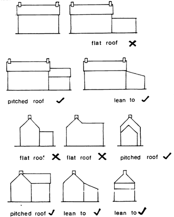
Extensions to existing structures must be a positive contribution
to the urban quality of the village. Such developments cannot occur
in a haphazard manner. Extensions must look like part of an existing
building and not like an unrelated appendage. Flat roofs are not
recommended. Where pitches and lean to roofs predominate they are
the proposed alternatives. The following diagram shows the type
of extensions which would destroy the symmetry of a building. (See
Diagram 1)
Infill developments within the village should complement the surrounding
structures. Existing houses should be studied and their basic proportions
interpreted in modern design. Fenestration must be in accordance
with neighbouring buildings, large areas of glass are particularly
out of character. Windows with a strong vertical emphasis are the
tradition in Ireland. Use of vernacular building materials is to
be encouraged. Existing building lines should be maintained where
possible as well as retaining common building heights and scales.
The fascia of new buildings adjoining older ones must be broadly
similar in terms of wall area and window area whether of vertical
or horizontal emphasis. Architectural detail on existing buildings
should be picked up in new developments helping to marry new structures
into their surroundings. Such details include eaves design or chimney
form and size. Hips should only be used on free standing houses
as they make it difficult to integrate housing onto the street scene.
The Council will continue to advise and support aesthetic improvement
works throughout the village. Planning Authority staff will continue
to liaise with the local development group or any other interested
parties concerning any newly suggested environmental improvement
works.
The Council will continue to assist with landscaping schemes through
funding, advice, and arranging contacts with other sources of funding
and advice. In particular areas such as the Pond, Shamrock and Graveyard,
rampant dereliction will be addressed.
| 15.0 Community
Facilities |
Current community facilities are generally well provided for in
the village. It is essential that this level of provision be extended
to all new residents. At present there are good school, recreational
and elderly facilities, which cater well for the existing population.
In order to cater properly for existing and future school numbers
current facilities must be upgraded to allow sufficient internal
floor space for recreational and assembly purposes. It is also necessary
to provide for expansion of grounds in order to achieve an acceptable
amount of active recreational land for school children. In the case
of Saint Sennans primary school it will be necessary, in the interest
of safety, to improve the quality of bus and private parking and
access. It is hoped that improvements in road safety throughout
the village will encourage increased pedestrian and bicycle use.
The provision of leisure facilities in Kilmacow is currently of
a high standard and this is in large measure due to the tremendous
local effort in the community. The extent of commitment to community
organisation in Kilmacow is impressive and gives the village a considerable
capacity for self generated development.
It is essential that the adequacy of these facilities be monitored
as the village expands and that provision is made for the expansion
of leisure facilities as the need arises.
There is space for further expansion within “The Farm”
area. It is hoped that these facilities will continue to be improved
by the local community and the County Council will endeavour to
assist where possible.
It is an objective of the Council
1. To preserve , provide for and improve recreational facilities
within the village.
2. To assist and co operate with the Kilmacow development Group
and other local voluntary bodies in improving amenities in the village.
3. To ensure that adequate and appropriate recreational facilities
are available to different age groups and different sections of
the community.
4. To facilitate the provision and expansion of primary school facilities
in the village.
5. To prepare a recreation plan to maximise the benefits of the
River Blackwater to the local community in conjunction with the
Kilmacow Development Group and the Southern Regional Fisheries Board.
Local employment opportunities are essential to the future of Kilmacow.
As the village develops employment opportunities will arise in the
provision of services locally.
The Council will endeavour to assist with the location of clean
light industry within Kilmacow and its wider hinterland.
It must be stressed that all the above improvements are subject
to the installation of the sewerage scheme. In light of this fact
it will be difficult to provide funding for improvement of community
facilities and the village in general before the sewerage infrastructure
is in place. Planned works for Kilmacow cannot be undertaken until
financial support has been sanctioned by the Department of Local
Government and the Environment. In effect this will put all major
improvement works on hold for the present. In the intervening period
it will be necessary to ensure that valuable development land does
not become sterilised and the County Council will enforce existing
policies to this end.
Once the sewerage network is in place general improvements in the
standard of road surfaces, footpaths and public lighting can occur.
These works will be given preference in the upper village as it
is in this area that the greater proportion of residential developments
will be encouraged. It is important to the overall standard of development
that separate areas are designed and completed as part of an overall
layout which could allow a combining of open space and pedestrian
routes.
The Planning Authority visualises that the upper village, Narrabaun
and Dangan shall be developed first. This area is the most central
to all existing services and has the greatest potential to be developed
as a “neighbourhood”, allowing a high level of interaction
between residents. The overall site itself can provide the greatest
potential for diversity in layout, densities and open-space, and
therefore could attract a greater cross-section of home buyers into
Kilmacow. It will also allow access from both roads in the upper
village while pedestrian and cycle access within the village would
be greatly improved with the completion of development in the area.
This factor would allow improved access for the existing residents
of the village, particularly those in Narrabaun to the schools,
thereby increasing overall road safety throughout the village. In
short development of this area would provide the greatest level
of return to the existing population.
Zoning will apply within the proposed development boundary. An
overriding objective of the Plan is to safeguard residential amenity
and prevent unplanned ribbon development. Upper Kilmacow is envisaged
as facilitating the greater majority of all development, it being
the core of the village itself. Further strengthening of a diversity
of uses in this area is to be encouraged. The village “street”
should comprise retail, commercial, community and other service
facilities. Outside this area such development should be limited,
particularly in the case of retail outlets. An indicative zoning
plan accompanies this plan.
In the following paragraphs:
• “Permitted use” means a use, which is acceptable
in the relevant zone. However, it is still the subject of the normal
planning process.
• “Open for consideration” means a use which may
be permitted where the Council is satisfied that the individual
proposal or development will be compatible with the policies and
objectives for the zone, and will not conflict with the permitted
uses and also conforms with the proper planning and development
of the area.
| 18.1 Rural
Conservation Area |
Objective: To provide for the development of agriculture and to
protect the rural character of the area.
Permitted Use:
Agriculture and related developments, outdoor recreation, rural
housing in accordance with the provisions set out for rural housing
in chapter 7 Vol 1 of the County Development Plan.
Open for Consideration:
Public Open Space, guesthouse, restaurant, Nursing home, dwelling
houses in certain limited cases as outlined in section 10.26, halting
site, private open space, other uses not contrary to the proper
planning and development of the area.
Objective: To protect, provide and improve residential amenities.
Permitted Use:
Dwellings, open spaces, places of worship, community centres, halting
sites, public service installation, playgroup or crèche,
Nursing home
Open for Consideration:
Bed and breakfast establishments and guesthouses, lock up garages,
retail shop of local convenience not more than 100m sq in gross
area, public house, hotel, restaurant.
Use by owner or occupier of part of a private residence as a studio,
for a light industrial activity, a clinic or surgery, professional
office, or as a playgroup or creche.
Objective: To provide for general development.
Permitted Use:
Dwellings, shops, wholesale outlets, offices, public buildings or
places of assembly, cultural or educational buildings, recreational
buildings, halting sites, hotels, motels, guest houses, clubs, private
garages, open spaces, public service installations, medical and
related consultants, restaurants, public houses, car parks, halls
or discotheques, and other uses as permitted and open for consideration
in residential zoning.
Open for Consideration:
Open space, workshop or light industry.
Objective: To provide for industrial and related uses.
Permitted Use:
Industrial premises and ancillary offices, open spaces, warehouses,
car and heavy vehicle parks,
Open for Consideration
Petrol filling stations, service stations, car showrooms, advertisement
structures, wholesale premises, public service installations play
school/creche.
| 18.5 Open
Space/Recreation |
Objective: To preserve, provide and improve recreational open space.
Permitted Use:
Open space, sports clubs, recreational buildings, stands, pavilions,
agricultural uses, public service installations.
| 18.6 Community
Facilities |
Objective: To protect, provide and improve community facilities.
Permitted Use:
Educational, religious and cultural facilities, public buildings,
playschools/crèches, schools, churches, hospitals, convents, community
centres and halls, school playing fields, colleges, orphanages,
hostels, halting sites, cemeteries, libraries and medical centres,
nursing homes.
Open for Consideration:
Public service installations
Applications will be considered case by case and assessment is
based on the general development criteria set out in the County
Development Plan. No extension of the area will be permitted.
Considered uses shall be confined to the following categories: Residential,
Open Space, Retail, Community facilities and Light Industrial.
By preserving characteristic features of the County, we seek to
maintain and nurture our cultural heritage as part of our identity.
The intrinsic value of the Kilmacow townscape, the areas of nature
conservation and the sites, monuments, and structures of historic
, architectural, artistic or technical interest is a major resource
for the development of tourism and economic development while contributing
to the quality of life. The sustainable management of this heritage
is a key priority. The Council will seek a balance of accessibility
and tourism development along with the conservation and preservation
of the protected structures and heritage items generally and their
settings.
Kilmacow has a rich heritage and through the policies and objectives
in Chapter 9 of Vol. 1 of the Development Plan the Council will
seek to maintain and preserve that heritage.
It is the policy of the Council to use its powers and available
resources to protect the architectural archaeological, historic
and artistic heritage of Graiguenamanagh both for its cultural and
tourism value in accordance with the policies set out in Chapter
9 of Vol. 1 of the County Development Plan.
| 19.1 Urban
Conservation Area |
In addition to the zoning objectives outlined above an urban conservation
area has been defined for the village and is shown on the zoning
objectives map.
In considering proposals for development within the urban conservation
area of the village it will be the policy of the Council to have
regard -
1. To the compatibility of the design and layout of the proposal
with the existing village fabric
2. To the impact of the proposed development on the existing amenities
and character of the area, particularly with regard to the scale
of building form, materials etc.
The following are the objectives of the Council:
It is an objective of the Council to seek the preservation/conservation
of the following structures:
| |
Protected
Structures |
|
| Dangan |
Grain Mill |
Three-storey mill on Black Water with traces of great spurwheel
gearing |
| Greenville |
Grain Mill |
Five-storey flour mill on left bank of Black Water near Kilmacow.
Francis turbine survives along with traces of machinery.
Impressive cast-iron aquaduct dated 1885 (by R. Graham of Waterford)
conveys headwater to mill (the wheelpit now houses a modern
electricity-generating turbine, 371:2). |
| Kilmacow |
Kilmacow Bridge |
Carrying a minor road over the Black Water the bridge comprises
6 equi-sized gothic arches (5 of which are in normal use); a
millrace is also accommodated on its western approach. |
| Greenville |
Grain mill |
Four storey mill with adjoining mill house, on left bank of
Black Water below Kilmacow. Undershot waterwheel, great spurwheel
gearing and millstones survive. |
| Dangan |
Dangan Bridge |
Six equi-sized semi-circular spans, with angled cutwaters,
carry a minor road over Black Water north of Kilmacow. |
| Catholic Church |
|
early C19th - totally modernised
but with elaborate late C19th gates |
| Three-bay, two- storey house |
|
West side |
| |
|
|
New Housing Design Policy
In new developments it is recommended that housing densities should
not exceed eight houses per hectare in Kilmacow.
The visual and physical characteristics of new developments in
relationship to their townscape and landscape context should be
considered. This includes
1. Views into and out of the site
2. Landmarks in the surrounding areas should be respected by new
schemes.
3. Existing movement and desire lines across and around the site.
4. Existing buildings on and adjacent to the site and whether they
should be retained.
New development should be a good neighbour to existing properties.
Sides and rears of buildings should not become a frontage to a new
road. In order to avoid domination by fences major roads and countryside
edges should be fronted by houses.
Housing should be laid out in such a way as to maximise proximity
to facilities and public transport.
No residential area should be more than 600 metres from a primary
school.
Development should be built around landscape structures such as
vegetation or built features to achieve uniqueness of character
in the development.
A legible network of paths should be designed based where appropriate
on existing trees and hedgerows. The street layout should be legible
structured by a distribution of distinctive spaces and places so
that it can be ‘read’ and thus it is easy to find ones
way around. See Kevin Lynches “Image of the City”, London
Press 1960.
The layout may in part be suggested by the topography, natural desire
lines and accesses to the site.
Cul de sacs preserve amenity and quiet but they also hinder pedestrian
traffic and make dead areas which are vulnerable to crime. Therefore
the design layout of housing areas consisting of Cul de Sac ends
requires careful planning.
A large residential area should have variation in character between
different parts to give the development a sense of place.
The development should have a clear and well defined external image.
This includes a clear urban edge, clear and well defined entrances
and a skyline which uses trees and tall buildings to structure the
external view.
The design should create the illusion of a rural environment in
a residential area. This cannot be achieved at densities over eight
houses per hectare. The visitor should be more aware of the landscaping
than of the houses. The lay out should be devised so as to allow
houses to appear as surprise features among the vegetation. This
requires a dominant landscape that has a significant density of
mature hedgerows and trees. Where vegetation is scarce it must be
rapidly established but this vegetation must be of a variety which
is not alien to the locality. Front gardens should be dominated
by hedgerows to allow the landscape to dominate housing.
The traditional buildings of Ireland are made up of rectangular
plans with pitched roofs spanning the narrower plan dimension. In
all elements the roof should be pitched over the shorter dimension
at 50 degrees. Such spans are rarely greater than 6.5 metres. In
buildings with bigger spans the traditional solution is to use parallel
roof spans (See Diagram 2).

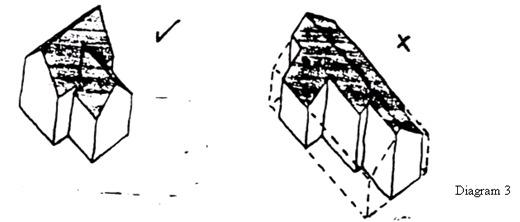
Buildings of more complexity should be composed of an assemblage
of rectangular forms for example L plans or T plans. Building should
be composed of a family of forms i.e. with roofs of similar pitch
consisting of a principle element to which subsidiary elements are
attached. Complex plans should not be enclosed in an enveloping
volume out of which pieces are cut to create subtractive forms.
(See Diagram 3)
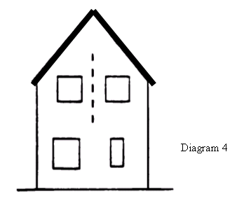
There should be a symmetrical pattern of openings
arranged around the central axis, preferable the front door. This
is crucial where the front elevation consists of a single gable.
(See Diagram 4)
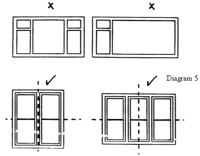
Unevenly subdivided windows can disrupt the balance of a building.
Windows should be symmetrical along the horizontal and vertical
axis. (See Diagram 5)
Deep plans should be avoided as it means back gardens must be inordinately
long to provide the minimum required open area. Deep plans also
present problems of over looking as they have aspects in all directions.
Dormer Windows
Dormer windows should only be a minor incident in the roof plane.
Their purpose should be to light the roof space not to gain extra
headroom over any great width. Rooflights should be used sparingly
and should appear on rear elevations only and not in conjunction
with dormer windows.
Gable Ends
The gable end in Ireland traditionally has a single centrally placed
window which reinforces the axis of the gable end and this practice
should be followed in new building.
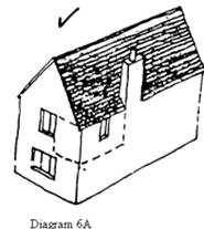
Traditional buildings normally have only one room in the gable end
with a single centrally placed window. Where a second room is unavoidable
the window of the larger room should be centrally placed on the
gable axis and that of the smaller room relocated onto the flank
elevation. (See Diagram 6A)
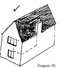
Alternatively a wider mullioned gable window may be used with the
partition of the second room butting up against the mullion. (See
Diagram 6B)
Departures from strict symmetry are possible as long as the central
axis is still strongly emphasised. The worst designs are those which
are not quite symmetrical. In the case of a wider frontage elevation
the need for centralisation is less great and asymmetrical arrangements
can look attractive. In such cases the front door is the most important
element and should form the basis of the pattern.
Windows
All windows and doors should be made of painted timber or p.v.c.
.Large unsubdivided panels of glass should not be used as they distort
the visual scale of buildings. A regular subdivision of windows
helps unify a building. A variation of subdivision can highlight
particular parts of the elevation eg the central axis of a gable.
Large patio doors can create the effect of a void. To counter this
large patio doors should be centrally located or located on an elevation
not shared with another window.
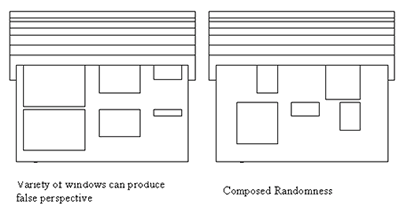
There is a tendency to use a specialised window for the purpose
it serves for example a small high level window for a toilet, regardless
of the pattern of openings this may produce. This must be avoided
as it can produce unbalancing effects such as false perspective.
(See diagram 7A)
‘Composed’ randomness may be used for a rear elevation.
(See Diagram 7B)
Garages
A large garage door can compromise the relationship of the dwelling
to the street. If the house is narrow fronted the effect is even
more dominant. A solution to this is to locate the garage in the
back garden with an access through an arch under the building. A
well designed timber door may also be acceptable.
The prominent positioning of garage doors at the end of a cul de
sac road junction or bend in the road constitutes a visual down
grading of the landscape. The solution is to be more flexible in
the positioning of garages so that they can be turned in various
directions or combined to form larger structures.
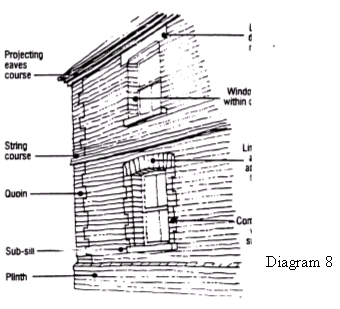
Modelling
Parapetted gables and eves are deemed satisfactory for roofing.
The form of the building may be emphasised by string courses, plinths
and projections at the eves.(See Diagram 8)
Chimney stacks help punctuate rooflines. For the purposes of fuel
choice houses should be provided with class one flues and chimneys.
They should be positioned on the ridge line of the roof either centrally
on a gable end or against an outside wall. On flank gable ends chimney
stacks should either be flush with the wall or else project sufficiently
that the stack has the visual strength to appear capable of standing
on its own.
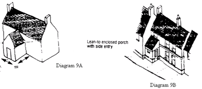
Porches
Porches should project from the building by at least as much as
they span (See Diagram 9A). Open porches are preferable to enclosed
ones. (See diagram 9B)
Over use of skin deep details should be avoided. Balconies must
be fully accessible. Bay windows must be substantial, preferably
storey high elements. Vent pipe outlets in roofs should either be
grouped and incorporated in chimney features or located on rear
slopes. Soil and waste plumping should be run internally and not
appear on the outside of buildings. Meter cupboards and service
intakes should either be located out of sight on flank elevations,
in ground level chambers, or accommodated in purpose made joinery
that fits in with the pattern of doors and windows on the elevation.
|